AnglingCharts


Lough Corrib Wallcharts


Lough Corrib Wallchart             

Lough Corrib A1 Depth Chart           

Lough Corrib Antique Wallchart
Lough Corrib A3 Laminated chart set
You DO NOT need a Paypal account to use the Buy Now buttons !!
A1 Chart and Shipping
A0 Chart and Shipping


A1 Depth Chart and Shipping


A1 Antique Wallchart and Shipping
A3 Chart set and Shipping
The Lough Corrib Antique Chart
Corrib Antique Chart
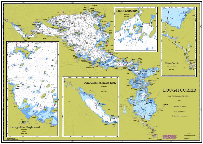
A beautiful antique style chart, in the style of the early 1800s. The chart has accurate depths and geography, all the island names etc.
Its a real eye-catcher and conversation piece, rather more than the "average map" !!

Comes in A0 and A1 sizes.

Please use the buttons above to purchase this chart, selecting your postage area.
The Lough Corrib Wallchart

An A1 or A0 size wallchart, on very high quality paper. This beautiful chart shows the main cruising routes, points of interest, and all of the lakes famed "shallows". It has highly detailed insets, including Oughterard and Inchagoill, as well as larger detailed coverage of Hen Castle and the North Lake.

It is updated with the new buoyage system,and contains locations of  launching areas and slipways.


It has local Angling Centres marked, historic wrecks and historic points of interest.


The Chart is shipped in a tough poster tube.


To order simply use the drop down menu above to select your shipping option.

Free Chart Download - The Lough Corrib Chart Book - Inchagoill
Inchagoill
Inchagoill Chart. Lough Corrib
A Free Chart to download. This is a page from the Lough Corrib Chart Book, now on Blurb and Amazon.com  bookshelves. See details here

It is also available in Charlie Byrnes in Galway, and signed copies direct from the author.

Simply click on the image to view it, right click to save (unless you have a Mac.....)
Lough Corrib Chart Book

This beautiful book has over 60 completely separate charts, from general charts to high resolution "pilot charts" all giving exceptional detail of bathymetry and topography.

Great for planning fishing expeditions, cruises and drifts, finding launch sites and places to visit.