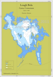
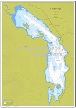
An A3 chart of Lough Bola, Carna, Connemara. Both a fascinating document and a very useful fishing map.
The lake is historically significant, with a well preserved crannog on it. The survey revealed the causeway to the crannog, running in an entirely unexpected direction, and with a deep hole across the causeway close to the crannog itself. This would have provided a great degree of security, as it would either have been bridged, or traversed by boat.
This is the only survey of the lake ever to have been conducted.
The Lough holds brown trout up to 1.5lbs, and was a good sea trout lake in years past. Photo Gallery
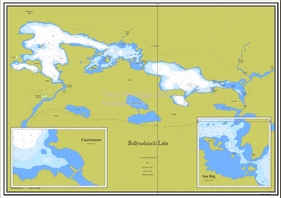
Click the image for more details.